


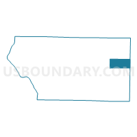
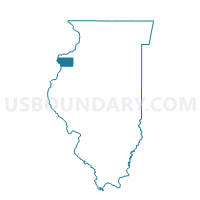
RIVOLI 1 Voting District, Mercer County, Illinois
About
Outline

Summary
| Unique Area Identifier | 573598 |
| Name | RIVOLI 1 Voting District |
| County | Mercer County |
| State | Illinois |
| Area (square miles) | 14.57 |
| Land Area (square miles) | 14.57 |
| Water Area (square miles) | 0.00 |
| % of Land Area | 100.00 |
| % of Water Area | 0.00 |
| Latitude of the Internal Point | 41.22095430 |
| Longtitude of the Internal Point | -90.49209460 |
Maps

Graphs
Select a template below for downloading or customizing gragh for RIVOLI 1 Voting District, Mercer County, Illinois


Neighbors
Neighoring Voting District (by Name) Neighboring Voting District on the Map
- GREENE 1 Voting District, Mercer County, IL
- LYNN Voting District, Henry County, IL
- OXFORD Voting District, Henry County, IL
- RICHLAND GROVE 2 Voting District, Mercer County, IL
- RIVOLI 2 Voting District, Mercer County, IL
Top 10 Neighboring County Subdivision (by Population) Neighboring County Subdivision on the Map
- Richland Grove township, Mercer County, IL (2,300)
- Greene township, Mercer County, IL (1,640)
- Oxford township, Henry County, IL (1,213)
- Rivoli township, Mercer County, IL (1,142)
- Lynn township, Henry County, IL (745)
Top 10 Neighboring Place (by Population) Neighboring Place on the Map
Top 10 Neighboring Unified School District (by Population) Neighboring Unified School District on the Map
- Sherrard Community Unit School District 200, IL (9,307)
- Alwood Community Unit School District 225, IL (2,398)
Top 10 Neighboring State Legislative District Lower Chamber (by Population) Neighboring State Legislative District Lower Chamber on the Map
- State House District 71, IL (104,867)
- State House District 72, IL (101,862)
- State House District 74, IL (100,949)